GNSS: Guide to the Global Navigation Satellite System
In this article, we look at the Global Navigation Satellite System (GNSS) from our own objective perspective. The aim is to provide you with a solid understanding of the basics and versatile applications of GNSS. We also highlight the challenges that GNSS faces, in particular jamming and spoofing. These interference attempts can impair the functionality and security of GNSS systems. You will also learn how we at MOBATIME tackle these security issues and what solutions we offer.
No time for reading? Here are the most important facts in summary about GNSS
- GNSS means "Global Navigation Satellite System" and is an overarching term for various global satellite navigation systems that are used worldwide for positioning and navigation.
- GNSS systems are critical to many modern technologies and services, from personal navigation, aviation and maritime to agricultural and geographic surveying applications. They provide precise location and timing information that is essential for a wide range of industries.
- Jamming disturbs the accuracy and possibly the positioning and/or time measurement by overlaying the GNSS signal with stronger interference signals.
- Spoofing involves the transmission of fake signals that resemble real GNSS signals but contain false positions and/or times.
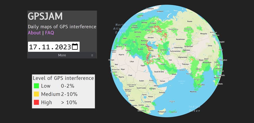
- On this website you can view manipulated GPS jamming signals worldwide in real time
Content
Definition of GNSS
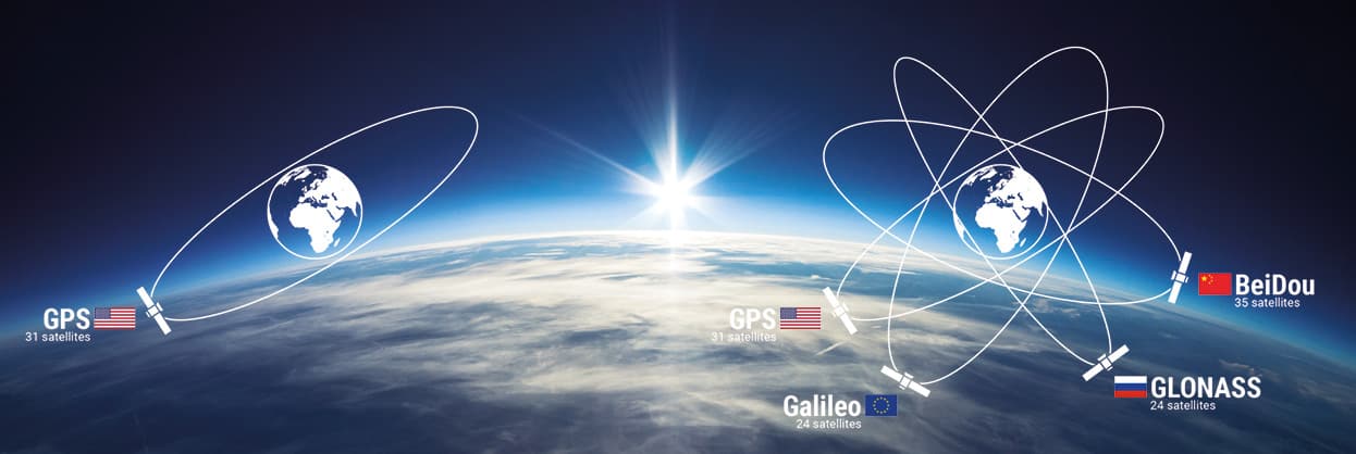
Global navigation satellite systems, or GNSS for short, represent a network of satellites that specialize in transmitting precise location and time information to Earth. These systems, which include the American GPS, the Russian GLONASS, the European Galileo and the Chinese BeiDou, are fundamental tools for modern navigation and positioning technologies. Their applications are diverse and range from everyday way-finding in smartphones to complex geodetic measurements and military operations.
Each of these GNSS systems utilities a constellation of satellites positioned in orbit around the earth. These satellites are equipped with highly accurate atomic clocks that enable them to transmit time information with extraordinary precision. This precise time information is essential for calculating the position, as it enables the distance between a satellite and a GNSS receiver on earth to be precisely determined.
The role of time synchronization
Time synchronization is an important aspect of how GNSS works. It is based on the fact that the transmission time of a signal from a satellite to the receiver is used to determine the exact position of the receiver. To do this, it is essential that the satellites' clocks and the receivers' clocks are synchronized.
- Any deviation, even in the millisecond range, can lead to significant inaccuracies in the position determination.
- This precise time synchronization is not only crucial for positioning, but also plays a key role in other sectors such as telecommunications, network timing and finance. In these areas, accurate timing is vital for the synchronization of transactions, data transfers and other time-critical processes.
- GNSS systems have continuously evolved over the years to provide ever greater accuracy and reliability. They are now indispensable components and play an important role in a wide range of applications.
Difference between GNSS and GPS
The main difference between GNSS and GPS lies in their scope and versatility. The Global Navigation Satellite System is a generic term that encompasses various types of satellite-based systems for positioning, navigation and timing (PNT) worldwide. The Global Positioning System is a specific system within this category.
GPS, originally known as "NAVSTAR" (Navigation Satellite Timing and Ranging), was developed in the 1970s by the US Department of Defence for military purposes. After the first satellite launch in 1978, GPS technology was quickly developed further and found increasing use in everyday life, especially after the switch-off of selective availability in 2000.
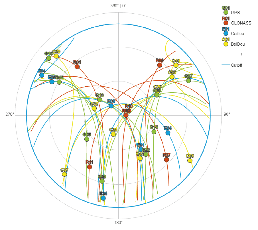
GNSS systems utilise satellite constellations and are based on the principle of trilateration, i.e. GNSS receivers determine their own position by measuring the distance to four or more satellites. These satellites can originate from different GNSS, as modern receivers are often multi-GNSS-capable.
For a long time, GPS and its Russian counterpart GLONASS were the only GNSS available. GPS became the most widely used GNSS due to its reliability - GLONASS suffered from neglect for a long time - and remains so to this day.
Jamming
Jamming is a type of "white noise" that causes loss of accuracy and possibly loss of positioning and/or timing. This means, that there is transmitted a signal on the same frequency like the GNSS-signal, but with significantly higher power. This type of interference can be caused by accident from neighboring electronic equipment or external sources such as amateur radio operators in the area or by intentional use of specific illegal jamming devices, which are specifically designed for disturbing GNSS-signals.
Case study: Airport traffic control systems
For efficient air traffic control, incident management, baggage logistics, security checks, passenger information systems and other processes, an airport traffic control system relies on accurate timing information. In our scenario, an intruder uses a device to deliberately interfere with GNSS signals in a specific area. If a time server is located in the disturbed zone, it will be incorrectly synchronized due to the impaired, inaccurate GNSS timing information or, in the case of a strong interference signal that completely blocks the transmission, it cannot be synchronized.
Consequences:
- The network overload causes delays in the transmission of the data required for time synchronization, which means that the clocks in the system are no longer synchronized.
- The inaccurate time synchronization results in coordination errors that have a negative impact on daily operations.
- Spamming attacks can also affect the security systems and cause dangerous situations, for example if the surveillance camera times are manipulated.
- In addition, considerable resources are required to combat the attack and normalize the system.
Spoofing
GNSS spoofing involves the deliberate generation and transmission of false GNSS signals. These signals mimic the real GNSS signals, but are designed to be slightly stronger and gradually overwhelm the real signals received by the target device. The goal is to trick the target device into accepting the fake signals as legitimate, resulting in false position or time data.
In contrast to jamming, where GNSS signals are simply jammed, spoofing is a more sophisticated form of attack. It requires a comprehensive understanding of the GNSS system and its signal structure. Spoofers must generate signals that are not only similar in structure to real GNSS signals, but also precisely timed to blend seamlessly with them. This complexity requires advanced hardware and software as well as technical expertise in GNSS technology.
The risks of GNSS spoofing are significant. They can mislead navigation systems, alter time stamps in financial transactions or disrupt critical infrastructure that relies on precise time and location data. Recognising and mitigating spoofing attacks is therefore of great importance for the security and reliability of systems that depend on GNSS data.
Are you now thinking that GNSS-spoofing is all just theory and is not widespread in practice? Then please read on now!
In a notable incident that calls aviation security into question, 20 aircraft were blown off course in Iranian airspace by falsified GPS signals. This event emphasizes the importance of cyber security and technological integrity in aviation. The exact cause and potential perpetrators behind these falsified GPS signals are not yet known. This incident raises important questions about security measures and defenses against such threats. Aviation authorities worldwide are now required to review and, if necessary, strengthen their systems to prevent similar incidents in the future
Manipulated GPS jamming signals worldwide in real time
GPSJam.org provides daily updated maps of GPS disturbances. These jams are determined using GPS accuracy data reported by aircraft. The website allows users to develop a global awareness of areas where GPS signals may be impaired, which can be critical for navigation and various GPS-based applications.
The website categories GPS interference into different levels of intensity. Although specific details about the levels may not be directly available on the website, it can generally be assumed that they range from "low" to "high" based on the degradation of GPS signal accuracy. This categorization helps users to better understand the extent of interference in different regions.
Daily updated jamming signals
One of the main features is the provision of daily updated data. The website is updated daily to provide the latest information on GPS interference worldwide. This ensures that users have access to the most up-to-date and relevant data regarding GPS interference.
Upcoming Trends in Jamming and Spoofing
As GNSS becomes more important in various fields such as navigation and timing, its security is also becoming more important. This is not just a technical issue, but a multi-layered challenge that businesses and organization must address in an evolving threat landscape. The threat landscape is also becoming more complex. It is no longer just about signal disruption; sophisticated attacks such as spoofing, where a false signal is sent to deceive a recipient, are becoming more common. These challenges are not static; they evolve as technology advances and require constant vigilance and adaptation.
Solution for protecting against jamming and spoofing attacks
GIDAS embedded from OHB Digital Solutions into the time servers DTS 4160 and DTS 4210.timecenter prevents the use of degraded or manipulated GNSS signals. The cutting edge-algorithms of GIDAS permanently monitor the quality of the signals received by the timeservers. In case there is detected a Jamming or Spoofing-Event the algorithm outputs an immediate alert and therefore prevents the timeserver from using unaccurate or manipulated time information. OHB inside protects users of MOBATIME time servers from GNSS vulnerabilities!
If you leave your system unprotected, you open the door to attackers. Given the critical role GNSS plays in a variety of areas, from navigation to time synchronization, the risks of an unprotected system can have far-reaching consequences. Even basic protections can act as a deterrent, making it difficult for attackers to exploit vulnerabilities. The ideal scenario is a comprehensive GNSS security strategy that includes real-time monitoring, regular updates and adaptive countermeasures to stay ahead of new threats.
Would you like to find out more about GNSS? Or are you wondering what measures you need to take now to be protected in the future? Then get in touch with us, we will be happy to advise you!

